| WPC Met Watch |
|
|
Mesoscale Precipitation Discussion: #1035 |
|
(Issued at 703 PM EDT Thu Sep 19 2024
) |
|
| MPD Selection |
|
|
|
|
|

Mesoscale Precipitation Discussion 1035
NWS Weather Prediction Center College Park MD
703 PM EDT Thu Sep 19 2024

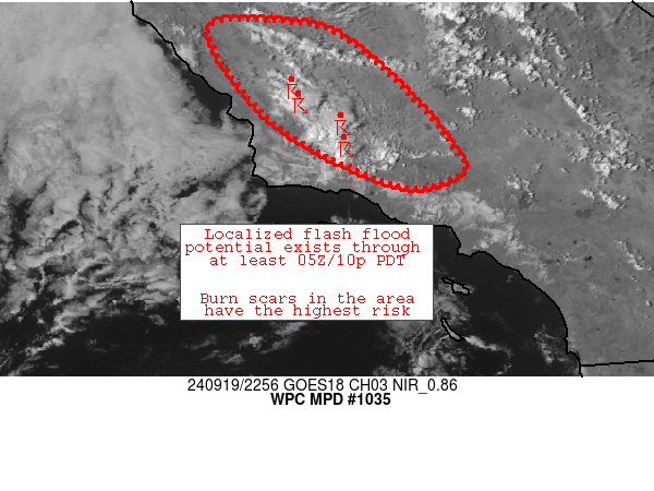
Areas affected...a small part of southwestern California

Concerning...Heavy rainfall...Flash flooding possible

Valid 192302Z - 200502Z

Summary...A few slow-moving thunderstorms have developed along
coastal ranges north of Santa Barbara.  Some of these downpours
were falling on sensitive areas from burn scars, potentially
promoting excessive runoff.  At least a few hours of locally
enhanced flash flood potential is expected.

Discussion...Abundant sunshine/destabilization beneath a cold
upper trough (centered near 34.8N, -121.3W) has fostered scattered
thunderstorm development near San Luis Obispo/Santa Barbara county
coastal ranges this afternoon.  These storms are very slow moving
due to weak mid/upper flow beneath the trough.  -17C temperatures
at 500 hPa was promoting areas of 500-1000 J/kg SBCAPE in vicinity
of the storms.  Additionally, despite modest PW values (around 0.8
inch), easterly low-level flow was promoting focused
upslope/orogarphic lift against the coastal ranges to promote
persistent updrafts and slow-moving downpours.  Areas of 0.25-0.5
inch/hr rain rates have been estimated per MRMS so far, with areas
of rainfall occurring close to sensitive burn scars across the
discussion area.

Heavy rainfall/flash flood potential will exist in portions of the
discussion area through/beyond 05Z per recent model guidance/CAMs.
 The persistence of this heavy rainfall regime is tied to expected
slow movement of the mid/upper low over the area.  Isolated areas
of 1-1.5 inches are possible in this regime.

Cook

ATTN...WFO...HNX...LOX...MTR...

ATTN...RFC...CNRFC...NWC...

LAT...LON   36232039 36071969 35431895 34861847 34621837
            34441887 34681960 35212047 36122109
Download in GIS format: Shapefile
| KML
Last Updated: 703 PM EDT Thu Sep 19 2024
|


